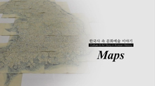
The Story of Culture and Arts
- Image resource of Korean history
- Documents from History TextBooks
- Culture & Art Stories from Korean History
- Culture & Art Stories from Korean History - Korean
- National Institute of Korean History
- History net
- About the site
- Introduce
-
Numerous topics related to Korean culture and art are mentioned in middle and high school national history textbooks, but most of them are briefly described by era, making it difficult to understand their concepts, transition processes, and characteristics.
<Culture & Art Stories from Korean History> produces and provides video materials based on expert commentary on the flow, change process, characteristics and characteristics of each major topic in the field of culture and art in Korean history.

Scenario
Digital maps are now created using cutting-edge information technology.
Using these maps, we can look at the areas we want to see at a glance and easily find routes. They provide a service we now cannot live without.
Maps were just as important and convenient hundreds of years ago.
So how skilled were our ancestors in mapmaking?
Is there a map created during the Joseon period that holds the record of being the world’s first?
The Cape of Good Hope, the southernmost tip of Africa, was discovered by a Portuguese explorer in 1488.
It was an historical watershed that opened the sea route from Europe to India.
However, did you know that a map that marked the Cape of Good Hope existed in Joseon Korea, 86 years prior to discovery by Dias?
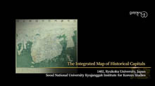
This is a world map created in 1402 during the rule of Joseon’s King Taejong. From its title, 'Integrated Map' means the areas that have formed a complete whole as the world, and 'Historical Capitals' mean the capitals in the past.
The Integrated Map of Historical Capitals is recognized as the first world map that marked Southeast Asia, Europe, Africa, and West Asia in addition to Korea, Japan, and China.
According to the postscript, this map was newly edited and referenced one map of the Joseon Dynasty, one map of Japan, and two maps imported from China. We can surmise from the detailed information available on West Asia, Europe, and North Africa that maps based on Islamic maps were used as references.
“You can know the world without leaving your home,
and knowing the distance between regions from the map
will help you rule this kingdom.”
Mapmaking was a national undertaking that was led by high-ranking officials.
What message was the Joseon Dynasty trying to convey through its detailed and precise maps?
The Joseon Dynasty drawn to a relatively larger scale!
A view of the world showing detailed information on not just East Asia but also West Asia, Europe and North Africa!
Through its world map, the Joseon Dynasty proclaimed to the world that a new era named Joseon had begun.
We live in a world where one can easily obtain information about one’s area with just a single map.
The map evolves endlessly to provide everything from practical everyday information to unique, customized information.
But did you know that a map just as detailed and informative existed in the Joseon Dynasty?
This amazingly detailed and precise map of Joseon Korea is ‘Detailed Map of the Great East.’
How did Kim Jeong-ho manage to create such a map that was far ahead of its time?
The Mystery Behind the Production of the Detailed Map of the Great East
Having the latest map was important to the Joseon government for administrative and military purposes.
This is why various maps of the country were produced from the early to late Joseon Dynasty.
Even among the maps that accurately depicted the shape of the Korean Peninsula, the Detailed Map of the Great East stands apart from other Joseon Dynasty maps.
The Detailed Map of the Great East is a foldable map comprised of 22 panels.
The various map sections can be carried separately for convenience or connected together for viewing various regions! It has a ground-breaking design that is both convenient and technological.
When all the panels are connected, it forms a large map measuring 3.8m wide by 6.6m long.
The most noticeable feature about the map is its depiction of geographical features. The range of mountains are drawn as ranges, and the lines have varying thicknesses that represent the size and height of the given mountain. This design sprang from the idea that mountain ranges are organic entities, like the frame of the human body.
Another unique feature is that the roads are drawn in straight lines.
On a black-and-white map, it can be hard to distinguish between a road and river.
This was a new attempt to avoid such confusion and clearly distinguish the two.
Also, the roads were functionally marked at every 10-ri to easily calculate distance.
Upon closer examination, you can note symbols like those found in modern maps.
The map provides various information, such as the locations of encampments, signal-fire stations, government rest stops, and royal tombs.
More information could be shown through the use of symbols.
The Detailed Map of the Great East is just as valuable and useful as modern maps.
To this day it amazes that Kim Jeong-ho was able to create such a masterpiece of the period.
Popular knowledge says that the map is so detailed because of the fact Kim Jeong-ho climbed Baekdusan Mountain multiple times and surveyed the entire country to make it. But, is this really true?
“The Detailed Map of the Great East is large, and as such, holds a wealth of geographic information. The locations of over 13,000 military facilities, counties, and townships such as place names and fortress walls are accurately marked. However, it would be extremely difficult for one person to survey the entire country and collect such a load of information in his lifetime. Master Kim Jeong-ho was an excellent mapmaker and geographer, whose work reflected the results of scientific mapmaking achieved by the government, the authorities, and the people in the late Joseon Dynasty, as well as the territorial and geographical information accumulated in geographical texts.” Yang Bo-kyung / Professor, Dept. of Geography, Sungshin Women’s University
Before he created the Detailed Map of the Great East, Kim Jeong-ho published various maps and even a book of geography.
This shows how endlessly he researched previously published maps and systemized varied geographical information.
In the late Joseon Dynasty, maps of counties and townships produced per administrative unit developed and played a large role in the production of the map of the whole country by supplying military, administrative, and geographical information for each local region.
During the Joseon Dynasty, maps were kept in government buildings and palaces where they were not easily accessible by the people. However, the Detailed Map of the Great East was printed using wood blocks, allowing its mass production.
This opened up a new era where people could look at places miles away through maps and use accurate and detailed geographical information to make life more convenient.
[Epilogue]
Must-Know Facts on Culture and Art in Korean History
1. During the Joseon Dynasty there were proactive efforts to create maps of the whole country as well as each county and township as a national undertaking
2. The Integrated Map of Historical Capitals, a map of the world produced in the Joseon Dynasty, was far more advanced than western maps of the period
3. The Detailed Map of the Great East, a complete map which integrated the production skills and geographical information of the Joseon Dynasty
Science and technology, Communication
10 films-
 Korean Typewriter04:37
 -
 Beacon Towers09:30
 -
 The Bow08:36
 -
 Ballistic Weapons09:06
 -
 Ships in Traditional Korea09:04
 -
 Papermaking and Printing Techniques09:03
 -
 Astronomical Instruments and Calendars During King Sejong’s Reign08:50
 -
 Honil Gangni Yeokdae Gukdo Ji Do02:18
 -
 Daedongyeojido04:07
 -
 Old Maps in Korea08:24